Tuesday, April 9, 2013

A Souvenir of Muscle Shoals, Alabama

Thursday, 4th April 2013

Map: Muscle Shoals, Alabama to Norcross, Georgia---261 miles

Doesn't Muscle Shoals sound like a gay resort?  Well, it's not---it's merely an archaic spelling of mussels.  And while the glossy magazine in our Key West Inn room pictured some intriguing sites along the river, touring 'The Shoals' was the last thing on our minds that dreary, damp morning.

A souvenir of Muscle Shoals, Alabama
The area is also known as the Quad Cities (Florence, Sheffield, Tuscumbia and Muscle Shoals) and we drove through them all out of curiosity.  At Muscle Shoals my husband demanded a stop at a small Loafs and Fishes Thrift Store, which I thought looked at best a dismal prospect---except for this delightful toilet bowl coffee mug for fifty cents.  We also found a curios tee shirt with lesbian overtones for Our Lovely Lesbians back in California for the same price, although it came with a few small holes on the back hem area in the bargain.  Oh well, they can wear it when they go out to feed their horses.

I loitered, listening to the rabid preaching of some radio evangelist as my husband cheekily presented the toilet mug to the cashier, a Southern Lady of a certain age.

"Oh my," she chuckled.  "I didn't know we had that on the shelves."  She started wrapping it up, and continued: "You know, my beautician has a funny picture at her station.  It's two cats looking into the toilet and saying the dogs highly recommend it."

The Pez head preaching fell away from my ears.  That's the way it should be: a nice Christian lady with a sense of humor volunteering at a thrift store.

We drove by Helen Keller's home in Tuscumbia, and I mused with my husband about how long she'll continue being on the pop culture radar---particularly out of the South.  The next day a younger second cousin assured me she was still big in school some fifteen years ago, but I'm more interested now in the radical, intellectual woman she became after the miracle---something the schools pointedly fail to mention.

There was an antique store in Sheffield of the likes that haven't been seen way out West in thirty years.  Piled and layered, it was full of good stuff---and while not particularly bargain-priced, the prices were reasonable.  We bought a pair of monk salt and pepper shakers---most appropriate for my husband---for four dollars, and a pair of circa 1950s cheesy plastic lady golfer cake toppers for a dollar.  Intended as a hostess gift on up in New England, the two lesbians will have to decide which of them is the golfer with the paint worn off her breast.

We left the Quad Cities area without even a whiff of knowledge about its music history---particularly strong in the 1960s with expected singers like Aretha Franklin and Otis Redding, and the less expected, such as George Michael recording an early version of Careless Whisper in Muscle Shoals in 1983.

Driving east on US 72, we stopped for an early lunch at Subway in Rogersville.  My husband, as usual, placed the order and came to an impasse when the woman behind the counter asked him what kind of meht he wanted.

"I'm sorry...?"

"MEHT."

"I---I don't understand."

She good-naturedly pointed to the trays of meats.

It was a better outcome than a few years ago in Tennessee, where he could not understand the sweet young thing behind the Subway counter and she couldn't understand his Way Down East accent.  I finally had to step in and interpret for them both.

We continued east through Athens and Huntsville, where everything is moon rockets.  The landscape becomes more interesting east of here, but unfortunately it was largely veiled by low clouds.  The area where US 72 crosses an arm of Guntersville Lake is particularly nice.

At Scottsboro we crossed the Tennessee River and climbed the palisades on Alabama 40.  Then we continued east over high rolling farmland and forest marked with extensive tornado damage at Henagar, where a mansion remained without most of its second story and roof.

We dropped back down into another old river valley on Alabama 117, driving through the little towns of Hammondville and Valley Head and climbing back up to Mentone in the aptly named Cloudlands region.  This is a popular vacation area, mindful of more Western terrain, such as California's Mother Lode in springtime.  Charming cabins and bungalows nestle in the beautiful forest.

Alabama 117 becomes Georgia 48 at the state line, and we dropped down into Menlo and its mixture of old orchards and vacation homes.  The drop continues to Summerville and US 27, which we cut away from again on Georgia 140 to avoid the congestion of Rome.  Exurbia creeps into view as we reached I-75 in Adairsville.

Time for a pit stop, and to be amused by two feral cats hunkered down in the mist at the drive thru menu at Wendy's, as if they were waiting to take some one's order.  I do forget to take photos, don't I?  Down the Interstate we stopped at a Dairy Queen for the obligatory Blizzard and found another cat camped out under a shrub with a can of Bumble Bee tuna.  The chafing outskirts of Atlanta definitely has a feral cat problem.

We largely avoided rush hour traffic by traveling in its opposite direction until we hit Sandy Springs on I-285, where an earlier fender bender and commuter traffic slowed us to a crawl---making for a forty-five minute drive for the last ten miles to Norcross.

Sunday, April 7, 2013

Iuka Not


Map: Russellville, AK to Tuscumbia AL---349 miles

Wednesday,  3rd April 2013

We camped out at McDonald's in Russellville Wednesday morning because the wifi at Motel 6 was flatulent.  The breakfast crowd was there, and the drive through line sometimes trailed out onto North Arkansas Avenue.  Generally the folks were hereditary rails or environmental whales; they both seemed to eat about the same amount of food.

At one point a little girl came in with her big daddy---one of those precious little Southern girls that look like they fell out of a Victorian print, all dirty blonde curls and sallow complexion.  She ran up to the faux pewter life-size statue of Ronald McDonald.

"Hi Ronald!"  She would have climbed up into his arms if Big Daddy didn't stop her.

On their way out, she sounded the obligatory, slightly sad Good-bye, Ronald---and I thought, wasn't there a television commerical like that?  But she was way too young to know that; to her, Ronald was simply the nice uncle who fed her.

We escaped McDonald's by some old residential streets.

"There's a lot of grape hyacinths in that lawn," my husband pointed out.  "You better take a photo."

"Aw, there like plumb in front of their door," I said in Arkie speak.  "That's like taking a picture of someone's underwear drawer.  They'll be more out in the country."

There were none, ever again.  My lament for the rest of the day and beyond was whar-yr's the Gee-Dee gra-ape high-an-this?!

We were motoring down old US 64, which featured an evacuation sign that my husband wanted me to photograph.  I waited for a great juxaposition, but the signs ceased before that happened.

"They'll be a Google image of it," I soothed.  But there is not. I liked the name: Nuclear One Evacuation Route---as if it was an escape from the Death Star, but I think he was most amused by a two lane road being an escape route. 

The towns of Morrilton and Menifee were stereotypically moldy and forgotten Southern towns---especially on that dreary day.  They might as well be a million miles off Interstate 40 instead of a mile or less.  They're fascinating in their own way, like driving through a novel.  Houses slump in on themselves out of pure exhaustion, trailers rot, junk radiates from either like an impact site.  Next door might be a McMansion or some venerable Southern mansion.

Wild verbena---an excellent title for a bodice ripper.
After the progressive city of Conway, the landscape opens up and rises a notch or two on the social scale.  Somewhere near Vilonia I forced myself to stop opposite a horse ranch and hike back to take a picture of an expanse of wild verbena, which is a pretty weed in those parts.  Here it's in its usual incarnation of rosy purple, but upon the rare occasion of thin, gravelly soil it changes to a very pretty blue violet.

Soon after we whisked by a circa 1970 trailer peeking out from the underbrush---one would have had to machete their way inside.  In front of it was a large patch of those golden narcissus.  Cold from my previous hike, I didn't stop to photograph the glory in front of the grim.

Beebe hasn't much but the two-year State University of Arkansas at Beebe and a Super Wal-Mart in the making.  It felt strange that the little downtown didn't have coffee houses and beer joints, especially since the school has been around since 1927 in one form or another.  I guess the collegiates just hang out at the Sonic Drive-In.

Vintage US 67, now Arkansas 367, heads northeast and displays all the evidence of a once-busy highway---mile after mile marked with abandoned gas stations, diners and curios shops.  It then dog legs into Searcy, a bustling city of jackrabbit drivers.  At a traffic light, we rolled up beside a car with a pastor's license plate.  He had a sign on his door that suggested a Biblical passage that for lack of an adverb or adjective made no sense.  I wish I directed my husband to take picture on the sly so we could study it later for possible interpretation.

Old US 67 reaches its climax at Bald Knob, which of course produced a very gay giggle within the confines of Patsy.  Bald Knob was once a big crossroads of old highways, and the whole place is devoted to those decrepit remains.  Some cafes are open, most are closed.  Motels are lived in by the month or open to the elements.  Perpetual yard sales display items dank from the seasons.  It was almost jar dropping in its squalor, which is probably why I didn't stop to take a picture.  I didn't have the backbone to answer the question wot are ewe takin' a pitcher of?  Not to say I didn't enjoy driving through Bald Knob---it's like a car wreck or some display of bad taste that you can't help but gawk at.

We headed east again on US 64, which had a constant westbound traffic of wide loads that caused trucks in front of  us to slow to gauge a bridge crossing with the wide ones.  It's a rather dull trip over the Mississippi floodplains squared for cotton and rice.

My husband required a pit stop at the crossroads of US 64/49.  He reported on the restroom and the vending machines therein:  "They sold Rough Riders and Tingle Rings."

"Did you buy me a Tingle Ring?"

"No---they cost seventy-five cents!"

"Humph!  Now I'll never know what they do."

I dimly recall such machinery in the men's rooms when I was boy.  They all seem to have retired to the Mason-Dixon Line, since I received a similar report from him in Tennessee several years ago.

We connected to Interstate 55 at Marion, where we went south and east over the Mississippi River to Memphis, Tennessee.  The freeway is charmingly vintage---at least until downtown, where signs vaguely inform the motorist to keep right to stay on I-55.  There were only two lanes to begin with, so I was surprised when we approached a cloverleaf and the two empty lanes went downtown, while all the traffic jammed onto a tiny southbound ramp.  Naturally we ended up going downtown, but upon seeing no real traffic for a dozen blocks or more ahead I decided to forget the freeway and just drive through town.

Downtown Memphis has had a lot of revitalization and fashionable people walked the streets but there was surprisingly little traffic.  There was an increase in traffic midtown, but hardly annoying or time consuming.  At one point I got confused about which highway I was following, as there were four combined at one point: US 64/70/72 and 79.  I wandered off through an elegant old neighborhood on 70 when I wanted 72, and it took me the Sam Cooper and Avron B. Fogelmann Expressways to get back onto track in the exclusive suburb of Germantown.  Before the Interstate system, getting sidetracked like this was a common occurrence.

Traffic was fairly heavy in Germantown, but compared to a similar California exurb it moved both smoothly and at reasonable speed, instead of flying from one signal to another.  Seen through the deciduous forest was subdivision after subdivision of huge brick homes sporting excessive gables.

US 72 enters Mississippi as a divided highway---one direction often being the undulating circa 1940 highway, while the other direction is the relatively flat modern road.  It was raining now, and the high rolling terrain disappeared into the mist ahead.

Cherry blossoms on the town square, Corinth Mississippi.
The meal of the day was at Martha's Menu in downtown Corinth, as recommended by Roadfood.com. Martha's is a cavernous cafe without decor, as all attention is focused on the marker board menu and the offerings of the day or  hour.  There is also a small printed menu, but I think I was the only one who accidentally consulted it that day.  Generally there's a choice of three entrees and three sides out of six.  This day offered the entrees of Breaded Pork Chop, Smothered Beef Liver or Swedish Meatballs.  The sides were white beans, broccoli with cheese, fried squash, coleslaw, creamed potatoes or potato salad.  I ordered the pork chop, fried squash, creamed potatoes and the broccoli and cheese.  My husband had the liver with the slaw, potato salad and squash.  Our bread of choice was cornbread because we couldn't understand the waitress when she said 'roll'.  She wrote this all down and then went to the board to wipe off the squash: No more of that.

We were early for dinner, but the place started filling up as we waited for our meal.  A huge elderly couple waddled in, she dragging an oxygen tank behind her.   They sat next to us, and another waitress took their order, her capacious rumble seat dangerously near. A cordless phone rang slightly above this protuberance.

"I've got to put you on howld," she said.  "I'm taking an order at a table."

That's how they handle takeout orders at Martha's, which appears to be almost half of her business.

Our food arrived promptly, which probably was a forewarning that it would be none too hot.  Fortunately it was delicious, and eating lukewarm food somehow seems Southern.  Only the squash was disappointing for sitting around too long.  My chop was chicken fried perfectly, the broccoli sinfully creamy with cheese and white sauce, the creamed potatoes as perfectly bland as the name implies---a dash of pepper made them perfect.  My husband's liver---the one on on his plate---was indeed smothered in a rich brown gravy, and although I hate liver I could tell it was very well prepared.  Probably the best thing of all was his coleslaw, which was surprisingly leafy green and freshly flavored.  The potato salad was Southern smooth and dotted with pimento.  I suspected it was made over creamed potatoes---and why the hell not?  It was the ultimate in comfort food.  Our cornbread was actually corn cake, as in pancake, and novel in neither being gritty or sweet.  Very good.

Mrs. Oxygen Tank had the Swedish meatballs and white beans, both tempting looking.  The beans reminded me of a pale rendition of Fina's green chili back in Chama, New Mexico.

By the time we finished, the peach cobbler for a dollar was also swiped clean from the board---not that we had any room for it.

I suspect Martha's is piping hot at lunch, or perhaps it is best as take out---where a nuking in your motel room microwave finishes her food off nicely.  With that in mind, Martha is indeed a delicious Southern Experience.

We planned to stay on down the road a piece in Iuka, but in spite of a fairly recent good recommendation on Google, no one was answering the phone at the Iuka Motel.  Out of curiosity, we got off of divided US 72 and drove the much more interesting circa 1940 highway in and out of town.  Although the Iuka Motel has yet to sink into decrepitude, it was obvious the few occupants were of the monthly variety.  A black Hefty bag of garbage sat outside of one room's door.

So we had to drive an extra thirty miles to my husband's Priceline find, the Key West Inn---a name to tie it into this unbeknown to us Mississippi tourist destination.  Never mind that Tuscumbia is about as Key West as Death Valley.


Saturday, April 6, 2013

April In Paris (Arkansas)

Tuesday, 2nd April 2013

Map: Watonga, Oklahoma to Russellville, Arkansas---349 miles

We woke up a bit later that we wanted---about five a.m.---but still arrived at Noble House for breakfast by 5:40.  We sat down in an empty dining room and waiting for something to happen, and then a woman who looked an awful lot like the woman who ran the motel bustled out.

"I'm so sorry.  I didn't hear y'all come in.  We use the back dining room in the mornin'---it's warmer back there."

Here sat several groups of old men.  In one group of four there was one in a big cowboy hat, two bare-headed and the last wearing a newsboy cap very similar to my husband's.  The burly man kept eying my husband and finally he tipped his cap to him.

"I just was admirin' your cap," he spoke up.  "These cowboys here are always giving me a hard time about mine."

Of course the cowboy had turned around at the tipping of his hat and cast a polite but knowing smile in our direction.  Strangers don't count.

Breakfast was absolutely delicious---simple and fresh. Upon hearing the option of rye toast, my husband ordered it to accompany his complementary eggs.  I suddenly felt the bread would be homemade, so I ordered simple white---and it was homemade.  The rye was swirled, which I haven't seen in a zillion years, and was very, very good---and I don't like rye. I had a Western omelet, and even the bell peppers were noteworthy sweet.

After we dashed back out to Patsy, we rolled through the dark empty streets of Watonga.

"I could live here," my husband said.

I turned and looked at him.  Usually it's me that says that about some dessicated old town, but he was hooked by the people we had interacted with.  After all, it was a community effort that brought back the Noble House.  So I told him about the male nurse---because it was pretty easy these people looked to how one contributed to the community instead of wasting most of their energy picking over the personal.

I was given the option of driving us into Oklahoma City, and it was found I had a knack for dealing with Patsy's ass-grabbing brakes---particularly if I had enough time to pump them gently, coast and pump again.  The most disconcerting thing was that the regenerative system seemed to be off, so when one took their foot off the gas, it felt like Patsy would coast all the way to New York City instead her normal slightly sluggardly roll.  Add the perfectly awful conditions of pitch black and pouring rain and it was one fun ride.

Eventually the rain slacked off and we came to drop in the prairie that revealed Oklahoma City on the far off horizon like the Land Of Oz.  Traffic was light as we rolled into exurbia and then into the dealership.

Courtesy was the keynote at Jim Norton Toyota.  We were subjected to it regularly as we sat in the customer lounge, where a pretty blonde receptionist would click in and ask if anyone need anything.

"A bottle of water?" she cooed.

I half-expected her to add 'cigarettes?'

Finally a woman piped: "How about a million dollars?"

"I'm sorry," the blonde smiled, "but I don't have that.  But if I did, you all could share it."

Which made us all laugh.

After a couple of hours, the mechanic supervisor came in.

"It's one of two things: either the auxiliary battery needs to be replaced or [a certain computer] needs to be replaced---and we hope it's not that because it costs a couple of thousand dollars and no one has it in stock.  The former is the likely culprit, as its voltage is only at 8.4, and that would make everything else malfunction.  So we'll start with that and rerun the diagnostics.  The estimated cost is $380 for parts and labor."

"It's probably just the auxiliary battery.  I had a friend who had a similar experience with her Prius."

His expression was opaque---I couldn't decide if he found this interesting or stupid.

"You also have a cracked drive belt and your tires are nearly bald," he finished.  "I'm just warning you about the tires because of this heavy rain.  Be careful."

The tire man said something similar before the trip, but retracted it---perhaps because he didn't want to pay the difference in the tire warranty.  Priuses are notorious tire eaters.  The tires still have some tread before they reach the dire wear indicators.

I was fortunate to have writing to do---the hours passed pretty painlessly.  If we could get out of there by noon, we could continue our trip without altering our schedule.  And they did finish by 11:40---and we were out the door with a new battery, less some $350 and a dashboard that displayed normally.  For all incidentals Patsy had amnesia, and it would take awhile for us to get her communications back to the way we like them.

It was raining now, and as we drove southeast and east through Oklahoma City it began to pour.  There's nothing worse than driving on the Interstate in heavy rain---all the cars kick up a mist and the visibility is nil, so I was glad when we were finally far enough from sprawl to be able to go south to Seminole and head east again on Oklahoma 9.  At least I could see better, even if my ears started hurting from the rain pounding on the windshield.  Patsy's mileage was abysmal, which I could blame on the rain, the high crosswind and mostly by the fact that she had been rebooted.  I've never understood that getting a tuneup was rewarded by bad gas mileage afterwards for a period of time.  It seems the engineer that could reward us by giving us excellent mileage after a tune up would benefit both the manufacturer and the mechanic with more positive reasons to bring 'er in.

There were some beautiful sights in the soggy gloom.  The lawns of older houses and often forlorn and abandoned ones were swept with swaths of grape hyacinths.  The intense blue violet color irradiated in the low light.  I was reminded of the late winter sweet violets in the old lawns of California's Central Valley, or the pale blue Ipheion uniflorum bulbs that emerge after the violets in old Chico lawns.  Neither is anywhere as spectacular as a large naturalized area of grape hyacinths joined with an equally endemic golden narcissus here in east central Oklahoma.  I wish I could have taken some pictures. 

Rolling to a stop at some country crossroads, we studied an elaborate sign for The National Infant of Prague Shrine, complete with the infant enshrined in glass: "The More You Honor Me, The More I Bless You."  I presumed Prague, Oklahoma was somewhere to our left or right, but later consultation of the map put Prague quite behind and to the north of us.  Obviously someone thought some advertising was the biggest honor of all.  The town's come hither: "Prague, Oklahoma---Come Czech Us Out."

We made a pit stop in Eufaula---a town I would of liked to have walked around if it wasn't pouring rain and some forty degrees.  The adjacent Eufaula Reservoir is a bit of a tourist attraction, which has kept Eufaula from falling into the typical Middle America downtown doldrums.  The Victorian business blocks are in good repair and appear prosperous.

Arkansas towns looked shabbier but no less interesting in the rain---well, except for Fort Smith, with was typical for the region suburban plexiglass and asphalt.

Paris was originally our stop for the night, but the one motel, the Paris Inn, had such bad Google reviews that we decided long ago to travel on to Russellville.  The motel looked good from the outside, and cars were unwittingly parked out front.

Coal was the leading industry here until the 1960s, and downtown Paris in the rain has the dingy, half-empty look common to old coal mining towns.  The most impressive building in town is the huge Gothic St. Joseph Catholic Church, followed by the tidy Federalist Logan County Courthouse in the city square.  East of town the Subiaco Benedictine Abbey and Academy sits like a holy factory on a hill---home to cowboy monks that raise black angus, vintner monks and monks that make hot sauce.

The real tourist interest lies twenty miles to the south at Mount Magazine, a historic state park high up on limestone cliffs.  The lodge there had been another accommodation consideration which we fortunately avoided, as it would have an expensive washout.  The area is noted for its extensive and varied butterfly population---including the rediscovery of the Diana Fritillary, once thought extinct.

So we ended up at the Motel 6 in Russellville, which one Google report said smelled like a locker room.  I found it smelled like celery cooking, with occasional suggestions of cabbage.  Sometimes and in some places it's just best to splurge a bit on your accomdations.

The consolation prize was Feltner's Whataburger across the street from the University of Arkansas.  Since it Easter vacation, it was unusually quiet---but as Roadfood reported, a collegiate was standing at the door, ready to write down your order on a paper bag, then your name and then hand it over to the cook.  We ordered two of their smaller cheeseburgers with everything on them, an order of onion rings and a lime phosphate---which the cashier/soda jerk(ess) suggested we make into a cherry-lime phosphate.  Of doubtful authenticity, it still was good.  She started off with Sprite, then squeezed a lime into it and floated another half in it, a squirt of cherry syrup and topped it with more Sprite.  The real lime cut the sweetness and made a very refreshing drink.  The hamburgers were old fashioned excellent, with all the condiments coming through individually instead of some secret sauce.  The onion rings were good but not exceptional.  We split a pineapple shake for dessert.


Thursday, April 4, 2013

Watonga Knights

Monday, 1st April 2013

Map: Raton, New Mexico to Watonga, Oklahoma---392 miles

Originally I had planned to drive east of Raton as everyone else does---southeast to Clayton and then northeast to Boise City, Oklahoma. But since it was so dry and that drive is solely prairie rolling ever lower, with only an interesting tiny stone bank in the almost ghost town of Des Moines as a distraction, I decided to head up the canyons northeast of Raton and proceed eastward over Johnson Mesa and then along the Dry Cimmaron.

These canyons once had fairly prosperous coal mines around the turn of the century.  New Mexico 72 heads towards the Sugarite Canyon State Park, but veers east up Brown's Pocket Canyon and through the site of Yankee, an early 1900s coal town.  Once lording over this location was the promoter Ensign's Ranch, a rural mansion with mahogany paneling throughout and the finest furnishings overlooking beautiful apple and cherry orchards.  The mansion lasted less than twenty years before being stripped and falling into ruin.  Today the area is dotted with trailers and is part of a cattle ranch.

Pronghorn antelope on Johnson Mesa
At the end of Brown's Pocket, New Mexico 72 twists around up to Johnson's Mesa.  Winter is so severe up here that there's a gate on the road to close during stormy weather.  It is a beautiful place of shallow ponds, cattle and antelope---and most of all, spectacular views to the northeast of the Great Plains.  Since we were just east of foul weather, it was too hazy to photograph the vista.  Some old farmsteads dot the mesa, but now only a few people live up there.

Main Street---Folsom, New Mexico
The highway drops down to another valley to the tiny living ghost town of Folsom.  Man has resided in these parts for thousands of years: In the early 1900s, archaeological discoveries here  first proved that humans had been in North America for at least 10,000 years, far longer than previously believed.

Folsom had peaked at around a thousand people when a flash flood hit the town in 1908.  Eighteen people died, including the elderly telephone operator, Sally J. Rooke, who stayed at her switchboard to ring up all phones and warn subscribers of the coming flood.  Those who didn't believe her frantic call died with her.  Her body was recovered the following spring about eight miles down the 'Dry' Cimmaron, and telephone operators from around the country sent in over 4,000 dimes to erect a monument for her in the Folsom Cemetery.  Unfortunately, when reading this story off a plaque in Folsom proper, it didn't mention where the monument was.  Folsom never recovered from the flood, and it's notable that what remains of the residential section is far removed from Main Street---the area most prone to flooding.

Folsom Hotel---possibly the site of a "notorious roadhouse" in the 1970s.
New Mexico 456 follows the Dry Cimmaron north and east for some fifty miles through often picturesque canyon country.  The ranches are few and far between, and after passing right through the yard of one, the road loses pavement for the next 17 miles---so we got our typical taste of dirt during a long road trip.  The surface had been recently graded,  smooth at the pavement for the most part and minimally dusty.  The canyonlands in this section are very colorful, rivaling western New Mexico and Arizona.  A new, wide bridge about midway along this section suggests that pavement may eventually be laid.

Back on asphalt, we noticed the haze growing strangely thick ahead.  The sun was still shining and it was 50 degrees, but within ten miles in Kenton, Oklahoma we were under low clouds and the temperature was 37.  Little Kenton is very remote but gets some visitors from the adjacent Black Mesa State Park.  There are some interesting sandstone block houses and buildings there, and it seems a number are used as vacation homes.  The one person we saw, a young man, stared back at us when we waved.

Many dreary miles brought us closer to Boise City, but not before my husband had to take a leak on the side of the road.  It was very bitter out---34 degrees, with a high damp wind bringing the chill way below freezing.

In threadbare, dessicated Boise City we stopped at a rather large thrift shop run by volunteers who directed the mentally/physically challenged at tasks in helping run the place.  We found it a rather amazing set up for such a small town.  Unfortunately we didn't find anything worth buying.

Another sixty miles brought us to Guymon, a more prosperous city of services and meatpacking.  In fact, we once ate delicious bacon waffles there at a restaurant next to a giant pork processing plant.  This time we only stopped to see the new Treasure Thrift Shop (or something like that) that we heard about on KGYN.  It turned out to be expensive and not very well stocked yet.

"How do you like your Prius?"

I turned around.  No one has asked us that in years.  There stood a pretty older lady with a halo of white hair and heavy plastic glasses, bringing in a bag for the proprietress.

"We like it very much---we have almost 300,000 miles on it."

"I just love mine," she said---love being the only indication she had a bit of an Okie accent.  "What kind of mileage are you getting?"

"Oh, around fifty to fifty-five."

She nodded.  "Once we came up from Dalhart with a strong tailwind.  I checked the mileage when we pulled into the driveway and we got 75 MPG.  I couldn't believe it!"

"Yeah,  we usually get around 63 coming off the Rockies and onto the Plains."  Although today we weren't.  I blamed the heavy cross winds, but the average so far was even below normal.

"That's the car I need!" chimed in the proprietress, as if we we talking about spacecraft.  I presumed the old lady had the only Prius in town.  We walked out to see her husband sitting in a new Prius in front of ours.

We switched drivers and continued east on US 412.  I had just dropped to sleep when I was rudely awakened by a ass-grabbing stop.

"What's going on?!" I yelled.  We were pulled over at an abandoned gas station.

"Something's wrong with the car.  The brakes don't work right."

The dash was lit up like a Christmas tree.  "Looks like the auxiliary battery has died.  All the lights came on when that happened to Joretta."

However, only the braking system lights were on---the brake light, a brake exclamation, the ABS and the VSC.  The owner's manual was no real help.

"Maybe something hit a brake line on the dirt road," I said---but we doubted it.

The brakes did work in a rudimentary way, and the synergy system still seemed to work and keep the battery charged, so the only thing to do was to keep driving.  At least we were in flat to rolling open country with few towns to deal with.  We hoped for a Toyota dealer in Woodward, some seventy miles away.

After whiplashing ourselves half way through the city of Woodward, Roland stopped at an O'Reilly auto parts store and I looked under the hood.  The brake fluid reservoir was within parameters.  I got back into Patsy, as it was only slightly warmer here than in Boise City.

"The nearest Toyota dealer is in Enid or Oklahoma City," my husband reported.  "Enid is a little closer."

"But to the north, so we might as well aim for Oklahoma City," I replied.

That would be another 150 miles of grab ass braking in increasingly congested traffic---and it was supposed to start raining.  Hard.

The original plan was to stay in Watonga and drive through Oklahoma City the next morning---which would still work, particularly if we left at the crack of dawn to get to the service department.

So after another hundred miles we came to a neck-snapping stop at the Watonga Motel.  The owner came trotting across the parking lot to the lobby, and in the lobby she had two nice cats.  Our room was big enough to hold a square dance in, had a comfortable bed and reliable Internet.  We also got a free breakfast at the Noble House downtown.

"What time do they open?"

"5:30," my husband reported.

"Perfect farmer's hours."

I found a number for Jim Norton Toyota on the Northwest Expressway side of Oklahoma City.  It was too late to be connected to the service department, but the operator was extremely helpful---putting a note on the service desk about our problem, when to expect us and our cell number.

"If you don't hear from them by 7:15, call me," she said.  "I should be in by then, and I can make sure they know your situation."

So---it was the best of a bad situation. 

Okay, no Watonga Knights in shining armor were involved.  The title of this piece was just a personal reminder about an online find I discovered:  an openly gay man in an Oklahoma town of 5,000 people.  As I plotted out our stops, I got into the habit of researching them online in a gay sort of way.  Usually nothing of interest came up for the small towns we were to stay in, but under Google images photos from online dating sites do sometimes appear.  And there was a chubby middle-aged gay male nurse with an ad---all rather sweet and charming.  There was even a photo of him with his mom, who looked quite a bit like that Guymon Prius woman.

Who obviously cursed our dear Patsy....


Wednesday, April 3, 2013

Fina's Diner

Easter Sunday, 31st March 2013

Map: Farmington to Raton, New Mexico, via US 64---299 miles

Jesus watched us leave Farmington without breakfast.  We drove east on US 64 through Bloomfield, which apparently anticipates a tremendous increase of traffic for their new six lane boulevard.  The highway quickly returns to its 1930s two lane self, gently climbing into the western foothills of the Rockies.  In the vicinity of Navajo Lake there is a very grand far vista of the San Juan Mountains to the north.

This is still oil country, the machinations of it all painted green to blend into the juniper forest.  Eventually we rise above the haze that has persisted over this part of the country, joining the deep blue sky and Maynard Dixon clouds almost close enough to touch.  Towards Dulce I recall wildflowers and meadows, but today only the sky is in springtime---the meadows were brown or covered in snow.

Chama was different, too.  It was still in hibernation, with the only activity crowding around the churches for Easter Sunday services.  The restaurant at the hotel was closed, so we backtracked to the US 64/New Mexico 17 crossroads, where we commented on a dive sort of diner, Fina's.  Might as well give it a try; it was 11:30 and we were hungry.

Upon entering, we practically ran over a tiny, ancient New Mexican grandma.

"Sit anywhere?" asked my husband as he scanned the six or eight tables.  Only one other couple was there, waiting for their order.

"Eh?"

"DO WE SIT ANYWHERE?"

"Oh---yeah, yeah."

We sat and a waitress eventually brought us some menus.  She had a bit of an attitude, although it was soon obvious that it wasn't about us but the fact that she rather watch the women's basketball game on the television.  She was of African American heritage, along with other pedigrees, judging by her mahogany skin.

The menu was unsurprisingly limited---typical diner fare plus a few Mexican dishes.  Instead of French toast for breakfast, there was Freedom Toast.  French fries were, of course, Freedom Fries.  The diner's decor reflected this attitude, although Coca-Cola nostalgia overruled all.

"Are you still serving breakfast?" asked my husband.

"No."

"Okay.  I guess I'll have the patty melt, then."

"Fries?"  I was pleased she didn't waste her breath on Freedom.

"Yes, please."

I decided on the beef taco platter, thinking it might be more of an experience.

A minute later she brought out two taco salads for the table behind us.  Hardly regional fare, but there was something about their appearance said authentic.  Instead of the chain restaurant grandiosity, the shells were smallish, golden and tight around a mess of a mixture.  My husband and I exchanged significant glances and lip smacks.

"Could we change our order to those taco salads?" he asked.

We were both surprised that instead of registering contempt our waitress seemed amused.  "Green or red chili?"

"Green," we chorused.

"Stop those orders," she shouted to the kitchen.  "They want salads instead."

She then settled into watching the television, where the game had yet to begin or had just finished.  They were interviewing a player---a light skinned African American.

"Come out here and look at her!" the waitress called to the kitchen.

"I can't," the cook shouted back.  "I'll ruin these shells if I leave them."

But soon the shells were finished, and the cook emerged and gazed at the screen.  I suspected she was Fina, a pretty middle aged New Mexican with a long, long braid.

"She's so pretty," the waitress said.  "Here brown eyes turn to green and back."

Her familiarity with the others suggested she was a family member, but I couldn't figure out if she was Fina's daughter or a granddaughter or more distant relation.  Later I could hear only snatches her conversation---about the daughter she'd have some day.

Our taco salads finally arrived---utter simplicity, being nothing but hand ground beef over iceberg over homemade chili.  At first I was annoyed by the lettuce being sandwiched by hot layers, but it worked---it stayed crisp enough, and it was fresh enough to exude a pleasing 'green' flavor.  The chili was the prize at the bottom of the bowl---beans just tender enough and mildly flavored, with a fairly clear heavenly liquor with a hint of heat at the back of the throat.  Towards the bottom the remains turned into a delicious tortilla soup.

"How were they?" asked the waitress as she picked up our empty plates.

"Absolutely delicious," we said.

She smiled and nodded.  "Good."

Business was picking up now.  Two middle-aged men came in and took a corner table.  The more handsome of the two kept eying me, and then got up and came over.

"You've probably guessed we're strangers," he began in a sing song Texas drawl.

"So are we," I smiled, but he didn't appear to hear me.  There was a certain affinity between us, and we weren't going to change our expectations.  He reminded me of some guy on Hee Haw---and God knows I never knew his name when I was some ten years old.

"So we need to know what's good here," he finished.

"The taco salad," I quickly replied.  "We just had one with green chili and it was absolutely delicious."

"Then taco salad it is," he smiled and nodded.  He thanked me and returned to his table.

We could overhear their order for taco salads, and the waitress was sure we did, too.  She breezed by us and murmured for our pleasure: "Well, this is turning out to be an easy day."

Oh, the guy from Hee Haw?  Google tells me the Texan was a more handsome version of Buck Owens...

Satiated, we continued on our road trip---passing the beautiful Palo Duro Canyon below Caprock Escarpment to the east.  New Mexico 512 goes right up to the head of the canyon, and we should have turned around and drove that short seven miles.  At least I knew US 64 climbed around Caprock and gave an excellent view of it from above.

Patsy commenced the climb to past 10,000 feet, slowing to a pedestrian 35 MPH growl on the steepest sections.  Extreme altitude is not her forte.  Fortunately the gradient isn't continuous and she had chances to recover.


Caprock Escarpment peeking over three feet of snow.
The vista point above Caprock was still snowed in.  We proceeded to cross the snow to get a clear view, but I promptly slipped up to my crotch in the snow.  After a third time in some thirty feet---and getting rather frightfully stuck the last time---I asked Roland to go on with the camera.  Since he weighs some sixty pounds less than me, he fared better---especially since he wasn't wearing cowboy boots that would hook three feet under the snow.  But he did have to crawl once or twice, so do enjoy his efforts...!


The radio station of the day was discovered here, just above the sea of static.  We enjoyed listening to Big Band Jump on 1490 KRSN out of Los Alamos all the way to Taos and a bit up Taos Canyon.
Looking west over New Mexico and Caprock Escarpment.

US 64 swings and sways through Carson National Forest and then Patsy flew down towards Tres Piedras.  Here the forest ends abruptly, as if crossing over into lazy neighbor's yard.  Sagebrush sweeps down to the crevice that contains the Rio Grande and back up to the snow covered Sangre de Cristo Mountains. Taos and its attendant suburbs dot the base of the range.

Before crossing the Rio Grande Gorge, we passed The Greater World Earthship Community---a Dr. Suess-esque development based on the sound science of local environment and recycling they call Biotecture.  Since my last passing of the locale, it seems they've grown from using bald tires to empty bottles.  Whimsical structures stood close to the highway, their walls a thousand glistening eyes facing southeast to southwest.  Rock-filled tires provide structure for the homes to burrow in the hillsides.

Taos is an interesting place.  I understand the spirit of it, its ancient history and the magic of different cultures and classes seeming to live in interactive harmony.  There really is no other place in America like it, and yet a stroll around the plaza reveals the typical dichotomy of catering to the rich and those who materially splurge.  Of course spirituality doesn't require austerity.  We all must make a living.  What pleases me the most is that time and commercialism hasn't buffed all the funky rough edges off the town.

Taos Canyon reminds me of the residential canyons of Southern California, and perhaps that is why I find it more interesting than the town.  This time of year the difference between living on the south facing or north facing side of the canyon is plainly evident, being that houses with a northern exposure were surrounded with snow and ones on the south are sunny and dry.

US 64 twists and turns over Palo Flechado Pass and drops into Moreno Valley adjacent to the Angel Fire Ski Resort.  It's a striking and unexpected alpine setting.  The highway continues to the north end of the valley and climbs around Eagle's Nest Lake before a long, gentle descent down riparian Cimarron Canyon to the town of Cimarron on the edge of the High Plains.

It is very dry here, and as we veer north northeast we come upon small herds of pronghorn antelope making a great effort to graze.  They hoove the dusty ground---digging for roots, I imagine.  At close range they have rather unbecoming faces, unlike most of their cousins.

We arrive at Raton early enough to scout out any vintage alternatives to Motel 6.  The Robin Hood seems the most viable, but also not very interesting.  Others, such as the El Kapp and the Oasis looked forlorn and deserted, so instead we drove around town to look at old houses and the interesting downtown.  It appears Raton was very prosperous in the first half of the 20th Century, and went into decline around the time Interstate 25 was built.  The plus side is that the commercial district wasn't made over much, so some 200 acres of it are now a National Historic District with almost a hundred buildings on the registrar.

We found Motel 6 to be very clean, but our non-smoking room smelled like a three pack a day smoker.

"Our room smells like tobacco," my husband reported.

"Smoking or chewing?" asked the desk clerk.

Having never been that close to a tobacco chewer, he didn't know how to answer---but he managed to get us another room anyway.


Monday, April 1, 2013

Bottles and Cans and Trash, Oh My!


Map: Zion to Farmington NM via Monument Valley---390 miles

Saturday, 30th March 2013

We breakfasted at the Pioneer Cafe in Springdale--where we have before, and with the same excellent results.  The place was surprisingly quiet for a holiday weekend.

The waitresses were all more or less sweet young things, all wearing the ubiquitous low rise jeans that appear to be attempting a reverse birth up their wazoos.  Will this butt-ugly (pun intended) fashion ever fade?  Wouldn't a slender woman feel more attractive with a waistband somewhere up near her natural waistline instead of being a fashionably fugly muffin top?  Judging by the harsh passive aggressive remarks a Facebook friend got after posting a vintage photo of her young and pretty self in circa 1976 high waist jeans, I was deeply irritated to realize even middle aged women dress not to please themselves or even potential partners but to seek social homogeneity with other women.  God forbid you actually like something around your waist, least it suggest the horror of granny panties.

I'm so glad I'm a man that can dress as he damn well pleases.  That's gay cowboy to you.  And it so happens my husband is in the middle of sewing me a pair of pantywaist jeans.

We threaded through Zion with about ten thousand other cars, but fortunately missed being held back so an RV could be escorted through the vintage 1930 Zion-Mount Carmel Tunnel.  Traffic thinned out past the eastern entrance to the park, and we enjoyed gliding down to Mount Carmel.

East of Kanab Utah on US 89
I've always liked Kanab.  I suppose we ought to stay there some time, although it never makes sense in our travels.  This day the turn here/turn there main street was under construction---which I swear was the same case several years ago.  This time there was the suggestion of a median being installed.  We continued on US 89, enjoying the red cliffs east of town.

Past the site of Paria, the highway veers south and drops into the desolate territory around Deep Water.  Even on a mild day the scenery evokes thirst, and by the time we got to Page I was craving a big Cherry Coke from McDonald's.  That's all what Mickey Dee is good for: piss stops and Cokes.  Yeah, they sorta go together, so the latter is now a rare treat.

We gassed up across the street (57.3 MPG from Cedar City to Page---it's predominately downhill all the way) and I moved into the passenger seat to take a nap.  I was sitting there, gazing off into space as my husband finished pumping the gas when I heard a short high speed skid.  I focused on the intersection nearby just to see a new black Camaro pull out into the path of a large pickup.  Twenty years ago it would have been a big smash up, but the truck's electronic stability control allowed the driver to veer off at the last second, still slamming the Camaro but with a more glancing blow.  Within a minute the sheriff was there, and as we drove off towards town another sheriff was on the way---as well as two Page Police. It seemed an overreaction, since the woman just sat in the Camaro, probably in shock and awe, not in any physical injury.

The wreck didn't really surprise me.  After all, we were in Arizona now, and I've witnessed more wrecks there first hand than anywhere else.  Arizonians are terrible drivers: fast, loose and unfocused on what's going on around them.  Obviously.

We left Page on Arizona 98, passing the coal burning Navajo Generating Plant and its attendant cloud of yellow smog overhead.  Soon thereafter we got stuck behind a Navajo carting a bladder of water in the back of his pickup over hill and dale while texting.  Add an unusual amount of traffic because US 89 slid down a mountainside south of town, it was awhile before we could get around him---at least longer than it took for the Arizonans to get around us both.

I awoke near the crossroads to Shonto to a familiar sight in these parts---at least to me: a sprinkle hitting the windshield.  This was perhaps the fourth time I've been over the Colorado Plateau, and Mother Nature has at least thrown some spittle at me.  That's all it would be today---the passing clouds congregating and parting, dropping and lifting veils of verga.

The desert grows interesting again driving east on US 160.  A north facing rim of rock captures moisture and the juniper grow larger and more numerous.  We pass under the coal conveyer coming off the upper plateau to a silo, the terminus to the electric railroad to the power plant.  At Marsh Pass a south-facing red rim joins in and homesteads grow more numerous in the colorful box canyons.

We switch drivers again at Kayenta, a town with an unprecedented amount of revivalist churches.  I hope they give the locals some spiritual succor, because the town is hardly uplifting.

Homesteads in Monument Valley
This is the first time we've taken US 163, the detour through Monument Valley.  As we move along in traffic traveling at anywhere between forty and eighty miles an hour the first thing that comes to mind is that there was no US highway here sixty years ago.  No pavement.  Probably a lot less homesteads, too---although that's hard to judge.  These homesteads don't thin much the farther one travels from Kayenta, but continue right in to the valley---a place I expected to be largely uninhabited.

When the movies used to come out here to make some grand Technicolor Western, it was quite an expedition.  I recalled the vaguely irritating documentary Chris and Don: A Love Story---and how writer Christopher Isherwood was invited to stay at one of these remote productions.  Don's recollection was of a very young man on classic road trip---and what the crew might have thought of him and his much older man.  This wasn't the set for a musical, after all.  Being one of those free-flowing documentaries, the movie was never named nor the invitee---I supposed Isherwood's voluminous diaries could be consulted for that---and apparently nothing was ever directly said of their May-September romance, as to be expected of the 1950s.  The scene in the documentary, like Monument Valley, is an enigma---history at once unrecorded, erased and rewritten to please the current audience.

I did not find a Monument Valley in all its VistaVision splendor.  The scale seems less dramatic.  Perhaps it was the day's opaque light---the homesteads, the numerous empty kiosks to fill for the tourist high season, the distracting glitter of beer bottles on the side of the road.  At closer range one could turn their back to these things, but then some of the sense of vastness was lost.  There is a natural energy to the place, a vitality of atmosphere colliding and colluding with a more solid brotherhood.  Perhaps I should have just closed my eyes.

Perhaps I should just forget about Chris and Don: A Love Story.

At times like these it's best to remember that there are no destinations in a road trip.  In the end it won't be the national park or other must-see one recalls first and foremost, but some fascinating moment in someone else's everyday world.

US 163 continues northeast, a surprisingly narrow ribbon unrolling downward over the broken landscape.  Behind us were often interesting far views of Monument Valley, although I wouldn't enjoy the long climb or searching out the few spots to pull off and enjoy the scenery.  It would be spectacular only in the morning light or at sundown.  Towards Mexican Hat the highway takes an even steeper pitch to the San Juan River, and Patsy really took off.

The San Juan Inn is perched on a ledge above the river, a very appealing situation and looking like a mid century modern resort that has seen better days.  The vibe wasn't any better---and upon consulting Google the many reviews have gone from good to bad in the last few years.  No one wants to be stuck in Mexican Hat with a misplaced reservation and no where else to stay.

Thee Mexican Hat
The sun decided to pop through just as we passed the locale's namesake, the Mexican Hat, making for a good if not common photo.

More off the tourist radar is The Valley of the Gods.  We didn't drive all the way in on the well-graded dirt road, but far enough to get an unobstructed view of the layered landscape.  As we waded across a shallow creek, we passed an old man beside his car, wiping down the slight dust and splatter with a napkin.

The Valley of the Gods
US 163 ends just outside of Bluff, Utah---a charming, threadbare old oasis and farm community on the floodplain of the San Juan.  Some ten years ago we enjoyed an excellent breakfast and atmosphere on the porch of the Twin Rocks Trading Post.  The place still looks sharp, and Google reviews all remark very good to excellent.

The scenery quickly degrades into oil country driving east on Utah 162, and becomes positively barren when the highway turns into Colorado 41.  It looks like it hasn't rained here for twenty years---the dirty orange clay merely whiskered with occasional stubble.  At US 160 again, I made a wrong turn to the right, into the sun.  I realized my mistake within a couple of miles, but not before gaping at the vast, sparkling sea of bottles on the side of the highway.  I wondered if the next car we passed would take a drunkard's serve towards us.

"We could spend a couple of hours here and pick up enough bottles to pay for this trip," I said.

"Or build a bottle house," rejoined my husband.

He was only a day off.  We'd be passing the bottle houses outside of Taos on Sunday.

I turned around and headed east on US 160 and then south on US 491 towards Shiprock.  The rock itself rose out of the desert haze, a gigantic monolith more majestic than anything in Monument Valley. Yet my attention was distracted by its distance, the traffic and the strange happenings along the shoulder of this desolate highway.  People parked out in the middle of nowhere as if by prearrangement.  A dog trotting along on some sixth sense.  Dead dogs that didn't make it.

Welcome to Farmington, New Mexico
I struggle to make sense of it all---to try to be honest about the natural beauty, the harsh lands and the trash.  If this nation had somehow continued in its own sealed off world perhaps it would be different.  But when an old Navajo begs for his granddaughter in the parking lot of Motel 6 in Farmington I probably feel as uncomfortable and disgusted as the earliest pioneers.  There has never been a cultural understanding between us, merely an uneasy truce over beliefs and promises left unfulfilled.  I may never hear the old man speaking his truth.

Sunday, March 31, 2013

...And Put $30 In The Bible

Friday, 29th March 2013

Map: Ely, Nevada to Springdale, Utah---257 miles

We breakfasted at the Silver State Cafe in Ely, although I really should have known better.  A rather lousy veggie omelet from years ago came to mind, as well as high prices.  I'd stick to a special this time---or it would stick to me, as it turned out.  Our eggs and solitary biscuit came from either Reno or Salt Lake.  The other apparently never made it.  It was a $3.95 Special for $5.49.  Note to self: The Hotel Nevada can't be as mediocre as this

“Out at Silver Valley?” an old man nearby spoke into his cell phone.  I found myself listening to him because unlike most cell phone users he spoke softly.  I took another bite of biscuit with floury sausage gravy.

“Yeah, we’d be better off burning coal,” he continued.

Looking east into Silver Valley on US 50 at US 93 South.  Mt Moriah to the left.
 And here we are, thirty miles east of breakfast---gazing across Silver Valley.  I always found it stirring in the morning light, the grand sweep between 13,000 foot Wheeler Peak and North Schell Peak to the northwest---the valley rising to the north like a wave from the past.  This morning Mother Nature is on a break.  It is still, and a forlorn haze veils the snowy mountains.  There is one new man-made feature in Silver Valley, the only one that stands out besides US 50---America’s Loneliest Highway.  It is a cluster of huge wind turbines, as still as the mountains.

I’ve only been here in the morning, and wind is not part of that memory.  The energy is all in the low light, sweeping in from the east and cutting out the landscape to the west.  But we’ve always taken from this part of the Nevada and moved the goods to supposedly better places.  And so we turn south on US 93, driving into the intolerable haze---an opaque proposition that doesn’t merely stand sentinel or craters the earth but literally sucks it dry.  Vegas, baby.  It’s Manifest Destiny, baby---and it’s thirsty.

What water?  The olive juniper and purple sage are mute---our nasty introduction, cheat grass, feigns a crisp golden silence.  Only a broad swath of burnt skeletons speaks of the present, only the name of the valley we drive into speaks of the past: Lake Valley.  The lake---more of grass than water---has sunk underground, and will continue to sink no matter who signs the damned if you do, damned if you don’t contracts.  Ranchers, ground down by drought, cheap beef and the whir of their pumps will be replaced by bigger pumps---and those who remain face an uncertain future, the water underground migrating to the highest dollar via a 263 mile pipeline.

A sign points to Atlanta that away.  There’s the water, towards the Utah boarder.  Sign here, governor of that state, or forget your rights to a share of it---forget your right to even protest.  It’s all here in print, but the politicians are simply turning the page.  The voters, smug in their sprawl, don't care anyway.

The sun rises higher, and the air slowly stirs.  White clouds start punctuating a bluing sky.  Dutch John Peak rises alone on the horizon, the ribbon of highway undulating over his flanks.  Ruggedly handsome, snow white on top, the old man is both green and burnt.  A photo opportunity, but there’s no shoulder to pull off on.  My eye trains along the edge of the road, searching for width but only finding bottles and cans glinting in the sun.  We pass the old man by.

Looking north into Pioche from old US 93.
Something new shining in the sun.  It is our own past; it is Pioche---the first town in 108 miles.  It was also our first stop in investigating this part of Nevada some dozen years ago.  The only apparent motel in town was full for some reason---who cares if it was a Friday. 

“They’ll have a room at the motel up the road a ways,” said the proprietress.  “You can call them from here.”

Having come from the south, we didn’t realize there was another one the very northern edge of town.  My husband said: “Oh, we’ll just drive there.”

“Oh, you can’t do that,” she explained.  “You must call.  And I’ll tell you what to say.”

She waved him into the lobby, dialed the number and handed over the receiver.  “When she asks if you’ve been there before, just say yes.”

An old lady picked up the call, said she did indeed have a room and took down our address and phone number.  My husband could hear the turning of pages over the line.

“And you’ve stayed with us before?”

“Yes.”

“Then you know the procedure.  The key is under the door mat and leave thirty dollars in the Bible.  You’re room number 3.”

“Thank you.”

My husband handed the receiver back and the proprietress smiled like the Cheshire cat.

The motel was of the 1930s---white clapboard, tidy and tiny.  The rooms sorta grew out from one another, and our double bed practically filled ours.  A defunct 1950s console television stood in the corner, taking up the rest of the room, and a modern television sat on top of that.  I was rather surprised there was even television provided.  The real amenity was out back: a rocky ledge jutting out over the desert---a quiet place to sit and take in the view reflecting the setting sun.

It’s still there, although the cheap 1970s era yellow plastic sign has faded to almost illegible.  A closed sign was tacked up to one corner of the building---closed forever or for the season?  Maybe the closed sign was there even when we stayed there.  The old lady would be ancient now, but the place and adjacent owner’s bungalow still looks tidy.

Pioche seems tidier than before.  The little Gem Theater with its 1940s neon marquee is closed---now playing is simply a thank you.  The other shops on Main Street look to be in business, although in all the town seems quieter this Friday than the one a dozen years ago.  There are some interesting houses, but none on the fancy side.  This was strictly a miner's---with shot gun cottages, bungalows, trailers and discordant modern vacation/retirement homes clinging to the hillsides.  The view to the north is spectacular.
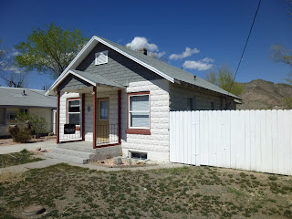
Faux granite block house in Caliente.
We glided past Cathedral Gorge and on down to Panaca, but instead of turning left to head to Utah we took a 15 mile detour down to Caliente to see a faux granite block bungalow for sale for $53,000.  We saw it on the internet, of course, and since we have an affinity for vintage block houses we made the trip.  

Caliente is definitely desert.  It's about two thousand feet lower than Pioche, with colored canyon walls rising all around it.  It’s the only place with city services outside of Cedar City, Utah, a hundred miles distance.  There’s a newish small hospital on the north side of town and a supermarket of sorts on the very forlorn and ancient business block along the railroad tracks.  A large and beautiful mission style Union Pacific depot appears to be used now to house city business.  The town seems to be inhabited by folks who haven’t the money to get out of town and those who moved there so they retire to permanent Weekend Warrior status---meaning raising some desert hell with their motorized toys.

Some of this new concrete has got to go...
The block bungalow was charming, particularly since it appeared neither neighbor had dogs.  Keeping your eye above street level avoided the drab trailer across the street and offered a view of the colored canyon walls.  Although the ad said it was a two bedroom house, it really was only one.  From a few uncovered windows we could see the living room across the front of the house, a dining room and kitchen, and an alcove hall with bath and bedroom.  It had a full daylight basement with vestiges of a second bathroom.  It appeared someone did a lot of work to it, such as rewiring, and then lost it.  The large back yard was a major asset.

Touring around the neighborhood, we saw another great house for sale---a tan baked brick bungalow on a very large corner lot.  The porch featured two front doors---one to the front bedroom, a common feature in railroad towns, where homeowners often rented out a room to railroad workers.  It appeared very original, but online consultation revealed some interior desecration---particularly an offensive 1980s kitchen with Formica Island.  It was a much larger house than it appeared: 3 bedrooms/2 baths/1600 square feet.  Built in 1935, it was in the Craftsman style with some Deco touches---such as the three banner style to the glass on the front doors.  Price reduced to $110,000.

We returned north to the crossroads to Panaca, a dessicated once Mormon oasis, and seeing a late Victorian block house wandered around the few streets, looking for others.  We found two.

Nevada 319 climbs to the Utah border through a lush, short juniper forest.  The views to the north are expansive.  Dropping over into Utah, the landscape thins, the highway joins the Union Pacfic and a few foundations and an imploded vintage trailer mark the site of Uvada.  Eight miles further northwest is the living ghost/railroad town of Modena.  The modern highway skirts the to bridge the railroad, giving the passerby a overlook at a handsome stone school, a fire house that appears to be remodeled into a residence, an abandoned hotel and a few old houses.  I rather regret not backtracking on Main Street once we crossed over the tracks.

Utah 56 veers east southeast across broad high plains dotted with old ranches and newer and rarely more successful ranchettes.  The number of buildings gives the impression of considerable population, but I doubt many are year around residents.  Spotting vintage trailers is one form of entertainment---they seemed to be the first form of homesteading, and sometimes more substantial than the buildings that replaced them.  Failed irrigation is marked by half dead fence rows.  At Beryl Junction the c. 1950 schoolhouse long ago turned into a general store which long ago closed.  Vintage cars and trailers fill the playground.

It's another ten miles to a modern gas station/mini mart at the cross roads to Newcastle, another thirty miles to Cedar City.  A swath of vivid red on the spectacular mountains that rise above town is the first impression of the basin, but then there are endless huge warehouses and finally the towering signs of commerce vying for attention.  I found sudden civilization irritating, as I do most of the I-15 corridor in Utah.  Rapid development in the last twenty years has pretty much destroyed a sense of individualism to the area.  Cedar City sharing a newspaper with St. George fifty miles south and three thousand feet lower is a perfect example of this modern homogeneity.

Cougar Mountain north of Highway 9, Rockville

Springdale.  The Sentinel to the left, Twin Brothers to the right.
Somewhat soothed by a Dairy Queen Blizzard (flavor: Heath Bar), we continued south on that mad rush that is I-15 past the beautiful Hurricane Cliffs and then a fast drop into the heat at Toquerville.  There are some cute old homes in town, and redbud trees flared like hot pink torches in the yards,  but the whole surrounding locale is being subdivided into lots and developments.  Only the red, broken landscape makes this tolerable; It is impossible to have  unbroken sprawl in Utah's Dixie.

Utah 17 took us to La Verkin, and then Utah 9 climbs over the cliffs to follow the Virgin River to its headwaters in Zion.  White thunderheads and deep blue sky accentuated the ruddy landscape.  An occasional small patch of purple verbena shone on the road's shoulder and ancient trees of the Prunus family were in full bloom around old homesteads.  Traffic was heavy.

The Sentinel from the Zion Park Shuttle.
We checked into the Pioneer Lodge, and the clerk apologized, saying that the room wouldn't be ready for another half hour:  "People around here don't like to come to work."  So we strolled midst the tourists on Zion Park Boulevard for awhile, the strip between the narrow sidewalk and street filled with grape hyacinths and daffodils.  A small leaved lilac that I'm not familiar with was in bloom in front of an old bungalow; I was disappointed in not being able to get close enough to it for inspection and sniffing.

After getting settled into our room (very nice), we walked down to a shuttle stop to go into Zion Park.  Although we've been to Zion before, we've never used them---being content to drive in during the morning and walk along the trails opposite the visitor's center.  Once understood, the system is great---being both convenient and free.  At least theoretically.  A driver told my husband he needed his [senior] pass to proceed to the inner park shuttle, so he trotted back to Patsy for it.  By the time we got onto a Springdale shuttle and disembarked to catch a park shuttle the kiosk and visitor's center was closed for the day---so one can get into Zion and be transported around for free after five pm.  Judging by the mob moving from the park to city shuttle, it's a good time to go, too.

Walking west along the Zion Canyon Scenic Drive
The shuttle takes about an hour and a half to make a complete circuit up and down Zion Canyon Scenic Drive---a drive closed to all other vehicular traffic.  Some stops are close enough together to make a great walk on to the next.  We did this twice, from Zion Lodge to Weeping Rock, and from the Grotto to Big Bend.  Although everyone takes the trails along the canyon walls, we found walking along the road offered the best all around vistas.

Virgin River
The hanging garden of flowers at Weeping Rock wasn't in season yet, but the view from there is worth the short, steep climb.  As the canyon fell into shadow, frogs started a strange song in the natural amphitheater that seemed to mimic the sound of water percolating through the rock.  The same shadows are a challenge for a rank amateur photographer such as myself.

A recorded tour guide drones along the way, telling us of the geographic landmarks in the vicinity.  After awhile, their campy names sound like a tour with Yma Sumac in The Secret of the Incas.  As the shuttle returns, the summary is thankfully silenced, leaving the passengers to the murmurs of tired hikers in several languages.

At Big Bend on the Virgin River
Having been in Yosemite just six weeks before, I felt a similarity between the two---surely more of spirit than geography.

Our shuttle returned to the Springdale at dusk---after giving us some three hours of both physical and spiritual exercise.